Approximate Location Map
Large Map »
Latitude: 52.9707 / 52°58'14"N
Longitude: -3.0913 / 3°5'28"W
OS Eastings: 326808
OS Northings: 342043
OS Grid: SJ268420
Mapcode National: GBR 71.JZJ2
Mapcode Global: WH785.HL5F
Plus Code: 9C4RXWC5+7F
Entry Name: Pont Cysylltau
Listing Date: 7 June 1963
Last Amended: 11 June 1998
Grade: I
Source: Cadw
Source ID: 1602
Building Class: Transport
Also known as: Pont y Cysylltau
ID on this website: 300001602
Location: Situated near a looping bend in River Dee between Trevor and Froncysyllte.
County: Wrexham
Town: Llangollen
Community: Llangollen Rural (Llangollen Wledig)
Community: Llangollen Rural
Locality: Trevor
Built-Up Area: Trevor
Traditional County: Denbighshire
Tagged with: Road bridge Stone bridge
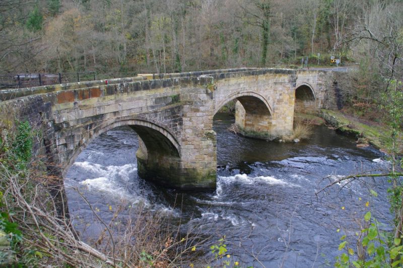
A road bridge over the River Dee. A date inscription '1697' has been recorded, and probably refers to date of the bridge's construction of which only the S arch and lower part of S pier survive. The remainder of bridge was rebuilt probably in C18 to a very slightly increased width. Parapets are now in relatively poor condition as a result of damage by traffic.
A 3-arched ashlared sandstone bridge with full-height cutwaters forming triangular refuges on both sides of narrow road. Segmental arches with slightly recessed voussoirs: S arch is shorter span and slightly narrower than the others. The S pier is twice stepped and the N pier is stepped once.
Listed as a fine example of a post-medieval bridge which still retains its original character, though slightly altered.
Scheduled Ancient Monument, DE027.
External links are from the relevant listing authority and, where applicable, Wikidata. Wikidata IDs may be related buildings as well as this specific building. If you want to add or update a link, you will need to do so by editing the Wikidata entry.


Other nearby listed buildings
