Approximate Location Map
Large Map »
Latitude: 52.9951 / 52°59'42"N
Longitude: -4.0958 / 4°5'44"W
OS Eastings: 259435
OS Northings: 346246
OS Grid: SH594462
Mapcode National: GBR 5R.H7K9
Mapcode Global: WH557.1ZW9
Plus Code: 9C4QXWW3+2M
Entry Name: Pont Aberglaslyn
Listing Date: 29 May 1968
Last Amended: 25 November 1998
Grade: II
Source: Cadw
Source ID: 3748
Building Class: Transport
ID on this website: 300003748
Location: Spanning the Afon Glaslyn approximately 1km W of Nantmor.
County: Gwynedd
Town: Caernarfon
Community: Beddgelert
Community: Beddgelert
Locality: Pont Aberglaslyn
Traditional County: Caernarfonshire
Tagged with: Road bridge
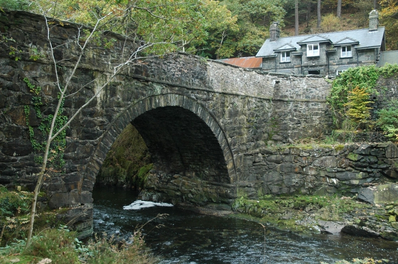
C17 road bridge, widened and heightened 1795-6 according to plans by James Deffard, architect. Restoration work in 1957 revealed the structure of the earlier bridge incorporated within the present one. Inscribed on the parapet were found the initials WM and the date 1656, together with the inscription 'Ric thom e Col Jes' (Richard Thomas of Jesus College).
Large single-span road bridge, approximately 15m long. Of rubble construction with wide segmental arch; rough-dressed voussoirs recessed below archrings of narrow stones. On the upstream side there is a plain, flat stringcourse below the parapet; on the downstream side the voussoirs are especially long and the stringcourse is gently pointed above the arch. Flat carriageway with slab-coped parapets, splayed at the W approaches and following the curve of the road to the E. At the former end are inserted milestones, probably late C19 or early C20; of slatestone with inscribed letters and figures. That on the downstream parapet is inscribed: 'To Portmadog 6 Miles' on the upstream side are 2 milestones, the first inscribed: 'To Beddgelert 1 1/4 Miles' the second: 'To Penrhyndeudraeth 6 Miles'.
Curved rubble revetment walls adjoin the parapets on both sides for some 25m, following the course of the road.
Listed as an C18 road bridge with earlier origins in a prominent location.
Group value with Bridge House.
External links are from the relevant listing authority and, where applicable, Wikidata. Wikidata IDs may be related buildings as well as this specific building. If you want to add or update a link, you will need to do so by editing the Wikidata entry.


Other nearby listed buildings
