Approximate Location Map
Large Map »
Latitude: 52.7758 / 52°46'32"N
Longitude: -3.2086 / 3°12'30"W
OS Eastings: 318567
OS Northings: 320487
OS Grid: SJ185204
Mapcode National: GBR 6X.Y137
Mapcode Global: WH792.PH9B
Plus Code: 9C4RQQGR+8H
Entry Name: Old Rectory
Listing Date: 28 January 2004
Last Amended: 28 January 2004
Grade: II
Source: Cadw
Source ID: 82429
Building Class: Domestic
ID on this website: 300082429
Location: To south of a minor road north of the River Cain, about 200 m west of Llanfechain Bridge.
County: Powys
Community: Llanfechain
Community: Llanfechain
Locality: Llanfechain village
Traditional County: Montgomeryshire
Tagged with: Clergy house
A large former parsonage, thought to have dated from c.1620; It was described in 1705 as a house of four bays and two storeys, and in 1730 as of five bays, three of which newly built. It was recorded as rented in 1736 and altered in 1739 and 1777. The thoroughness of the 1851 work and the uncertainty of C18 definition of the word 'bay' render it difficult to interpret the verbal evidence for the earlier form, but the part one would now refer to as the southern part of the three western bays of the house has a symmetry and integrity, internal as well as external, suggesting this is the historic core.
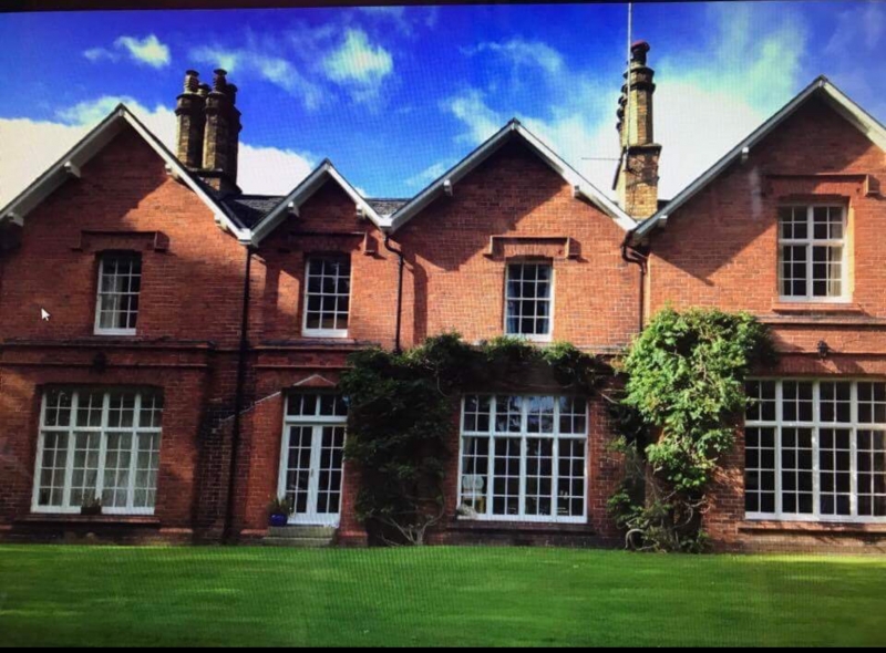
The house was radically altered by Edward Hodkinson for the Rev. Maddocks Williams (rector 1851-72) in 1851. The house now faces south away from the road, has large windows on its front to the lawns, and has been enlarged at east and north and entirely encased in Ruabon bricks. It is illustrated after this enlargement in M.C. (1872): it is in the picturesque domestic Tudor style often considered appropriate for parsonages (as, for another example, Llansilin parsonage).
The Rectory ceased to be a parsonage in c.1980.
A large and picturesque two-storey house in red brickwork in regular stretcher bond (suggesting advanced use of cavity construction?) and with Tudor details. Slate roofs with four gables to north and south; generous overhang to eaves and verges. The roof has an east-west spine range, linking all four north/south ranges.
The 1851 enlagement has produced a curious mixture of symmetry and asymmetry in the front elevation to the lawn at south. The upper windows of the three left bays are 12-pane hornless sash windows, possibly retained from the earlier core of the house; the upper window of the right bay and the lower windows of all four bays are of an innovative C19 design with mullions and transoms, incorporating lower sashes beneath fixed upper lights. There is a door in the second bay from the left similarly beneath a transom and overlight. All of the window and door openings have segmental arches, chamfered arches and jambs, and brick label moulds. There is probably a string course at mid height (concealed by ivy) as on the side and rear elevations.
The entrance to the house in its present form is to the east, in an elevation with two gables incorporating C19 mullion, transom and sashes windows; at right below is an open-fronted porch with a plain door.
The north elevation shows the gables of the same four north/south ranges as the south; it has horned 12-pane sash windows above and cross windows below, except for the lower window at left (mullion, transom and sashes) and at right (a sash window similar to those above).
The three west bays are planned quasi symmetrically with a narrow hall and stairs enclosure. The stairs are of simple Regency type with inch-square balusters on a closed string and a plain handrail. Panelled doors and door casings.
A fine example of a big Victorian parsonage, of uniform picturesque Tudor style notwithstanding its development from a smaller pre-Victorian house.
External links are from the relevant listing authority and, where applicable, Wikidata. Wikidata IDs may be related buildings as well as this specific building. If you want to add or update a link, you will need to do so by editing the Wikidata entry.


Other nearby listed buildings
