Approximate Location Map
Large Map »
Latitude: 52.3072 / 52°18'25"N
Longitude: -3.0922 / 3°5'31"W
OS Eastings: 325632
OS Northings: 268237
OS Grid: SO256682
Mapcode National: GBR B2.WPF4
Mapcode Global: VH76V.C84N
Plus Code: 9C4R8W45+V4
Entry Name: Church of St Mary
Listing Date: 24 October 1951
Last Amended: 16 March 1992
Grade: II*
Source: Cadw
Source ID: 9108
Building Class: Religious, Ritual and Funerary
Also known as: St Mary's Church, Pilleth
ID on this website: 300009108
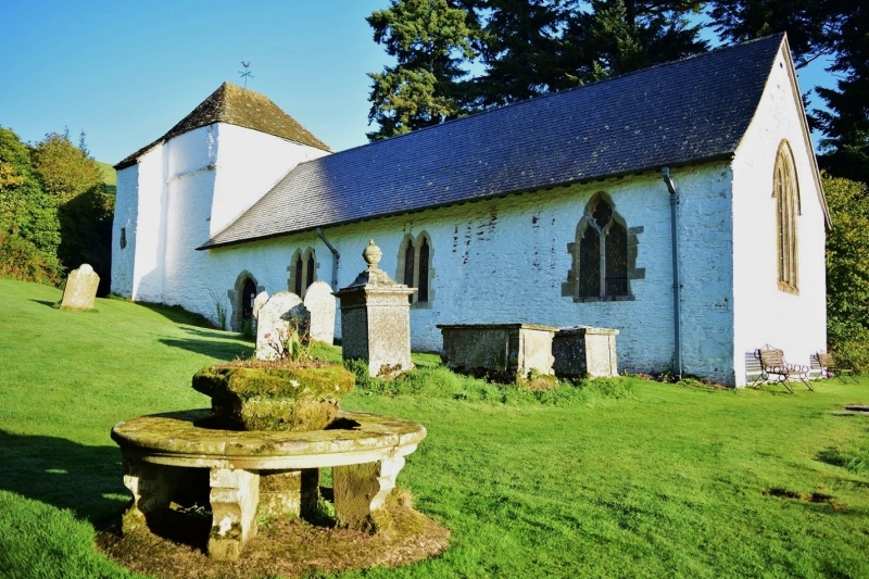
Location: Beautifully located on a prominent platform site on the lower slopes of Bryn Glas, lying just above Pilleth Court and the B4356 Presteigne to Llangunllo road.
County: Powys
Community: Whitton (Llanddewi yn Hwytyn)
Community: Whitton
Locality: Pilleth
Traditional County: Radnorshire
Tagged with: Church building
Lies close to the site of the Battle of Pilleth 1402 when Owen Glendower defeated Sir Edmund Mortimer.
Probably C14 on an ancient site, rebuilt in C15 after partial destruction by Owen Glendower. Extensive repairs were undertaken in 1872/73 to the specifications of Charles Hill of Knighton, including the partial rebuilding of the east wall, a new east window and two new windows in the nave. The church was gutted by fire in 1894 and subsequently reroofed and refurnished by Walter Tapper in 1911.
Coursed sandstone rubble with freestone dressings, temporary felted roof to nave by Tapper at a lower level; earlier roof lines are visible on the east wall of the tower. Tower retains stone tiles. Single cell nave with paired lancets by Hill, south door with pointed arch. Sanctuary end has north and south two-light windows with Decorated tracery and cusping. Broad C15 tower with string course and south west stair turret, both reduced in height with later saddle-back roof. Small narrow lights in turret and fragments of C15 tracery reset in west window of tower. Portions of older foundations and buttressing visible on the north west corner.
Churchyard: Three flights of shallow cobbled steps, flanked by rubble walls with flat stone caps, designed by Tapper. Inset memorial tablet to Pryce Hughes d1914.
To north of tower a Holy Well. Simple rectangular hole in the ground lined with rubble stone except for the rear which has exposed natural rock face; reached by five steps. Formerly roofed over and of repute for healing properties in the Middle Age. Two chest tombs and distinctive square box tomb with ball top.
Typical Radnorshire plain interior with fragments of old wall plaster. Low, recapped stone bench around west end of nave. C14 font, octagonal with scalloped undersides, restored and set on base designed by Tapper. Flat ogee-headed piscina in sanctuary and corbels for a Lenten beam. Two C17 chairs, lobed stoup of c1200, and stored in the tower, C17 communion table and medieval dugout chest. Medieval bell frame for three bells, one survives of c1450 cast by Richard le Beleyetere of Worcester, inscribed "Sancta Radegunda ora pro nobis".
External links are from the relevant listing authority and, where applicable, Wikidata. Wikidata IDs may be related buildings as well as this specific building. If you want to add or update a link, you will need to do so by editing the Wikidata entry.


Other nearby listed buildings
