History in Structure

Pont Faen

A Grade II Listed Building in Llangernyw, Conwy

More Photos »
Approximate Location Map
Large Map »

Coordinates

Latitude: 53.1919 / 53°11'30"N

Longitude: -3.6816 / 3°40'53"W

OS Eastings: 287749

OS Northings: 367407

OS Grid: SH877674

Mapcode National: GBR 69.2S78

Mapcode Global: WH65S.F13C

Plus Code: 9C5R58R9+P9

Entry Name: Pont Faen

Listing Date: 23 June 1967

Last Amended: 17 March 1999

Grade: II

Source: Cadw

Source ID: 99

Building Class: Transport

ID on this website: 300000099

Location: The bridge carries the road from Llangernyw to Llansannan across the Afon Cledwen 250m E of the village centre.

County: Conwy

Town: Abergele

Community: Llangernyw

Community: Llangernyw

Traditional County: Denbighshire

Tagged with: Bridge Road bridge

Find accommodation in
Llangerniew

History

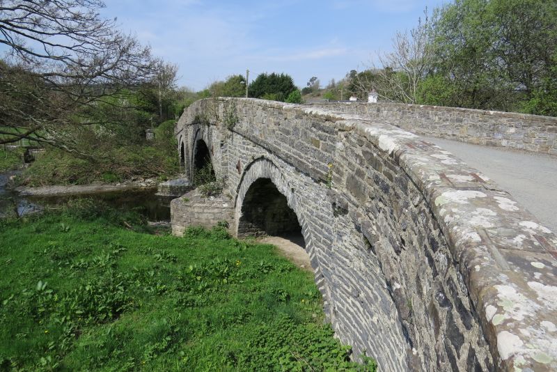
Probably built in late C18.

Exterior

Road bridge, gently cambered, built of local stone rubble with three segmental arches springing from water level each capped with projecting regulating course. The central arch which is wider than the others has a projecting composite key stone and is flanked by shallow pilasters which rise to the top of the parapets. Spandrels of long, flat rubble slabs rise to a projecting cambered string course at road level above which the parapets of roughly squared rubble are coped with flush sandstone slabs linked with iron cramps. Later sandstone cutwaters added to piers on S side. At each end parapets sweep outwards and terminate in square piers.

Reasons for Listing

Included as a fine unaltered example of a larger type of bridge typical of the improvements to commercial routes between rural communities carried out in the late C18 and early C19.

External Links

External links are from the relevant listing authority and, where applicable, Wikidata. Wikidata IDs may be related buildings as well as this specific building. If you want to add or update a link, you will need to do so by editing the Wikidata entry.

Recommended Books

Other nearby listed buildings

  • II Sandbach Mausoleum in churchyard of Church of St Digain
    The mausoleum is situated on the N side of the E extension of the churchyard, approximately 100m E of the church.
  • II Ty'r Ysgol
    Ty'r Ysgol adjoins the E end of the former village school below and approximately 30m SE of the Church of St Digain, and is entered through a gateway leading from the school yard on the W side.
  • II Group of 2 Monuments in churchyard to Church of St Digain
    In the E section of the churchyard, approximately 30m E of the chancel of the church, within an area defined by four trimmed yew trees.
  • II Youth Club
    The youth club stands below and approximately 30m SE of the Church of St Digain, on the NE side of school yard, entered from a gateway on the W side.
  • II* Church of St Digain
    The parish church stands S of the centre of a roughly oval-shaped churchyard on the S side of Llangernyw village centre. The churchyard is entered through a lychgate at W.
  • II Raised Slab Monument to Harry Lloyd in churchyard of Church of St Digain
    In th SW section of the churchyard, adjacent to the S wall of the church vestry.
  • II Lychgate to Church of St Digain
    The lychgate is situated on the W side of the churchyard, close to the centre of Llangernyw village.
  • II General Store
    The building stands on the W side of the A548, approximately 40m N of the centre of Llangernyw village.

BritishListedBuildings.co.uk is an independent online resource and is not associated with any government department. All government data published here is used under licence. Please do not contact BritishListedBuildings.co.uk for any queries related to any individual listed building, planning permission related to listed buildings or the listing process itself.

British Listed Buildings is a Good Stuff website.