History in Structure

Boer War Memorial & Railings

A Grade II Listed Building in Town (Y Dref), Merthyr Tydfil

More Photos »
Approximate Location Map
Large Map »

Coordinates

Latitude: 51.7478 / 51°44'52"N

Longitude: -3.3738 / 3°22'25"W

OS Eastings: 305251

OS Northings: 206352

OS Grid: SO052063

Mapcode National: GBR HP.102N

Mapcode Global: VH6CY.GBRG

Plus Code: 9C3RPJXG+4F

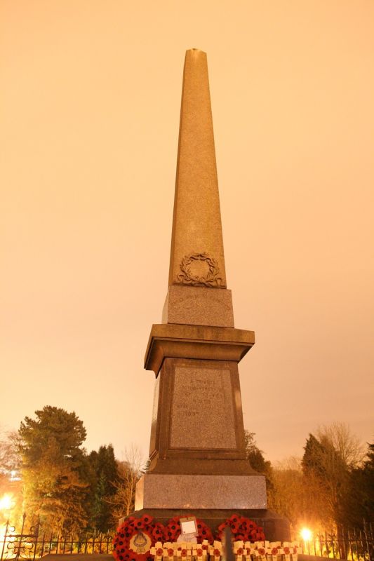
Entry Name: Boer War Memorial & Railings

Listing Date: 13 January 1988

Last Amended: 13 January 1988

Grade: II

Source: Cadw

Source ID: 11469

Building Class: Commemorative

ID on this website: 300011469

Location: Set away from road on a modelled, grassy hillside overlooking the town centre; recreation ground to N.

County: Merthyr Tydfil

Community: Town (Y Dref)

Community: Town

Built-Up Area: Merthyr Tydfil

Traditional County: Glamorgan

Tagged with: Obelisk War memorial

Find accommodation in
Merthyr Tydfil

History

Unveiled Sept 1904 by Lord Windor. "A Tribute to the memory of Merthyr Men who died in the South African War 1899-1902". Prepared in Aberdeen from designs by Washington Morgan sculptor (inscription on plinth).

Exterior

Tall, granite obelisk with inscribed polished granite inscriptions on tapered sides. Carved wreath to W face, moulded cornice and plinth to pedestal, stepped base.

Square, railed enclosure with spears to sinuous wrought-iron Art Nouveau panels; dwarf stonework walls.

External Links

External links are from the relevant listing authority and, where applicable, Wikidata. Wikidata IDs may be related buildings as well as this specific building. If you want to add or update a link, you will need to do so by editing the Wikidata entry.

Recommended Books

Other nearby listed buildings

  • II Primrose Hill
    Detached house at top end of Church Street where the road turns at right-angles into Bryntirion Road.
  • II Merthyr Christian Centre
    On an elevated site against the hillside with gabled front closing the view up Church Street.
  • II Bryn Heulog
    High above road behind walled garden.
  • II Sunny Bank
    High above road behind walled garden.
  • II St Tydfil's Hospital: Entrance Block (Centre Part Only)
    Set to rear of railed forecourt with drive leading diagonally to plain opening in right-hand range. Union Place approaches on left.
  • II Statue & Plinth to Sir W.T. Lewis
    To left hand side of entrance forecourt at St Tydfil’s Hospital. Relocated from original site outside the General Hospital, Penydarren Road.
  • II Springfield Villa
    Uphill from Rectory and reached by a diagonal roadway from Bryntirion Road near Sandbrook House. Detached in walled garden.
  • II Newton House
    Pair of terraced houses stepped in slope towards Church Street.

BritishListedBuildings.co.uk is an independent online resource and is not associated with any government department. All government data published here is used under licence. Please do not contact BritishListedBuildings.co.uk for any queries related to any individual listed building, planning permission related to listed buildings or the listing process itself.

British Listed Buildings is a Good Stuff website.