History in Structure

Primrose Hill

A Grade II Listed Building in Town (Y Dref), Merthyr Tydfil

More Photos »
Approximate Location Map
Large Map »

Coordinates

Latitude: 51.7471 / 51°44'49"N

Longitude: -3.3748 / 3°22'29"W

OS Eastings: 305183

OS Northings: 206267

OS Grid: SO051062

Mapcode National: GBR HN.15TZ

Mapcode Global: VH6CY.GC71

Plus Code: 9C3RPJWG+R3

Entry Name: Primrose Hill

Listing Date: 22 August 1975

Last Amended: 13 January 1988

Grade: II

Source: Cadw

Source ID: 11425

Building Class: Domestic

ID on this website: 300011425

Location: Detached house at top end of Church Street where the road turns at right-angles into Bryntirion Road.

County: Merthyr Tydfil

Community: Town (Y Dref)

Community: Town

Locality: Thomastown

Built-Up Area: Merthyr Tydfil

Traditional County: Glamorgan

Tagged with: Architectural structure
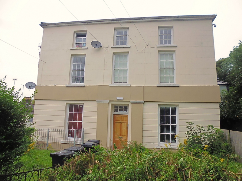
Find accommodation in
Merthyr Tydfil

History

Early to mid C19.

Exterior

3-storey, 3-bay cement-rendered elevation, ground-floor rusticated. Hipped tiled roof. Smaller pivot windows without glazing bars to second-floor; sashes with glazing bars to lower floors. Simplified pilastered doorcase with modern door and fanlight. Small enclosed forecourt with right-hand gatepiers.

External Links

External links are from the relevant listing authority and, where applicable, Wikidata. Wikidata IDs may be related buildings as well as this specific building. If you want to add or update a link, you will need to do so by editing the Wikidata entry.

Recommended Books

Other nearby listed buildings

  • II Merthyr Christian Centre
    On an elevated site against the hillside with gabled front closing the view up Church Street.
  • II Bryn Heulog
    High above road behind walled garden.
  • II Sunny Bank
    High above road behind walled garden.
  • II Former Unitarian Chapel
    Set in terraced row close to corner with Church Street.
  • II Newton House
    Pair of terraced houses stepped in slope towards Church Street.
  • II Newton House
    Pair of terraced houses stepped in slope towards Church Street.
  • II The Rectory
    Detached T-plan house set on hillside with road curving forward from right above.
  • II Boer War Memorial & Railings
    Set away from road on a modelled, grassy hillside overlooking the town centre; recreation ground to N.

BritishListedBuildings.co.uk is an independent online resource and is not associated with any government department. All government data published here is used under licence. Please do not contact BritishListedBuildings.co.uk for any queries related to any individual listed building, planning permission related to listed buildings or the listing process itself.

British Listed Buildings is a Good Stuff website.