Approximate Location Map
Large Map »
Latitude: 53.6005 / 53°36'1"N
Longitude: -2.8376 / 2°50'15"W
OS Eastings: 344666
OS Northings: 411874
OS Grid: SD446118
Mapcode National: GBR 8VMT.G1
Mapcode Global: WH86B.CRZN
Plus Code: 9C5VJ526+6X
Entry Name: Ainscoughs Mill
Listing Date: 17 December 1998
Grade: II
Source: Historic England
Source ID: 1033375
English Heritage Legacy ID: 471861
ID on this website: 101033375
Location: Burscough, West Lancashire, L40
County: Lancashire
District: West Lancashire
Civil Parish: Burscough
Built-Up Area: Burscough
Traditional County: Lancashire
Lieutenancy Area (Ceremonial County): Lancashire
Church of England Parish: Burscough Bridge St John
Church of England Diocese: Liverpool
Tagged with: Building
SD41SW
663/2/10004
BURSCOUGH,
MILL LANE,
AINSCOUGH'S MILL
17-DEC-98
II
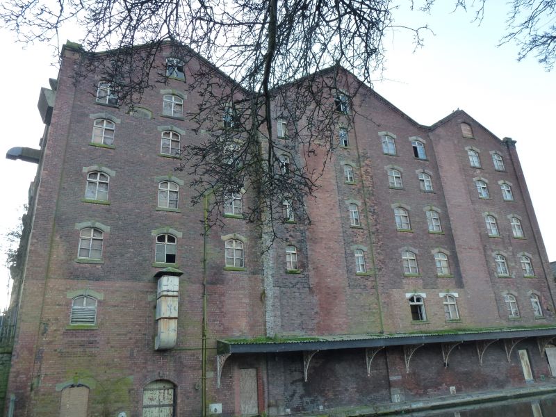
Former steam-powered corn mill, empty at the time of inspection ( October 1998). c.1858, extended 1885 and 1894 by Hind and Lumb, and with further late C20 additions and alterations. Red brick with ashlar sandstone dressings and slate roof coverings.
PLAN: Irregular L-plan, comprised of a NORTH-EAST RANGE , facing onto the Leeds-Liverpool canal, a SOUTH-EAST range facing onto the Liverpool to Preston railway line, and a POWER UNIT with boiler house, engine house and chimney.
NORTH-EAST RANGE: faces onto canal to north-east. Triple gabled range of 6 storeys with attic floor, six bays long. Wide central gable, with 4 windows to each floor, formerly with hoist canopy between windows to left-hand side. Narrower gable to left with 3 windows to each floor, and to right, with 2 windows per floor, to left of former hoist canopy. Extending the full length of the frontage, a continuous canopy providing covered unloading facilities fro m the adjacent canal wharf. To the rear of the adjacent power unit, a 5 storey wing with narrow gabled ridge ventilator extending the full length of the building, and now with C20 corrugated sheeting to cheeks. Narrow gable with 3 windows to each floor, many now blocked.
POWER UNIT: L-shaped complex attached to north-west side of north-east range, with tall tapering circular chimney rising from a square plinth, and set between an extended and altered boiler house and to south- west, a 2-storey engine house with decorative brickwork to eaves and verges. South-west gable with windows flanking central double doorway to each storey. Cast iron lintels to door openings.
SOUTH-EAST RANGE: 2 wide gables to right of tall square water tower on north-west side. This has a wide basket arched opening to the ground floor set within a surround of rock-faced sandstone, giving access to main body of mill. Tower of 5 storeys, extended or re-built by a further 4 storeys, with shallow corner pilasters and a plain parapet. Semi-circular headed windows to each floor. To left, 6 storey range links with north-east range. To right, wide gables extend south-westwards, with blocked openings to each side. C20 door inserted into base of left-hand gable. C20 extensions to south-west end are not of special interest.
INTERIORS: boarded floors supported on deep timber joists and spine beams carried on cast-iron columns with splayed and bracketed heads. Wide span composite roof trusses carry multiple purlins. Underboarded roof spars. C20 milling and cleaning machinery throughout, ( removal taking place at time of inspection).
HISTORY: The mill was developed by Hugh Ainscough in 1855 on the site of a former windmill. It was strategically sited next to the Leeds-Liverpool canal and the Liverpool- Preston railway , and was able to transport and process imported wheat from the port of Liverpool.
A substantial and near-complete example of a purpose-built steam powered flour mill, sited close to canal and rail links with Liverpool and the Lancashire coalfield, demonstrating the scale and detailing of a mid-late C19 industrial milling complex.
Listing NGR: SD4466611874
External links are from the relevant listing authority and, where applicable, Wikidata. Wikidata IDs may be related buildings as well as this specific building. If you want to add or update a link, you will need to do so by editing the Wikidata entry.


Other nearby listed buildings
