Approximate Location Map
Large Map »
Latitude: 51.7466 / 51°44'47"N
Longitude: -3.3757 / 3°22'32"W
OS Eastings: 305123
OS Northings: 206216
OS Grid: SO051062
Mapcode National: GBR HN.15MK
Mapcode Global: VH6CY.FCSD
Plus Code: 9C3RPJWF+JP
Entry Name: Former Unitarian Chapel
Listing Date: 13 January 1988
Last Amended: 13 January 1988
Grade: II
Source: Cadw
Source ID: 11457
Building Class: Religious, Ritual and Funerary
Also known as: Former Unitarian Chapel
ID on this website: 300011457
Location: Set in terraced row close to corner with Church Street.
County: Merthyr Tydfil
Community: Town (Y Dref)
Community: Town
Locality: Thomastown
Built-Up Area: Merthyr Tydfil
Traditional County: Glamorgan
Tagged with: Chapel
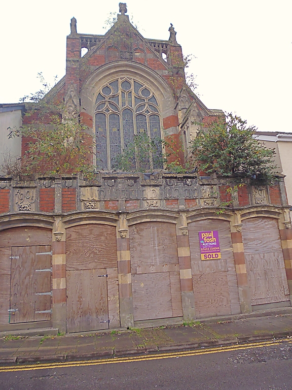
Dated Dec 1901 (foundation stones). Designed by E A John(ston) FRIBA, architect of Abergavenny and Merthyr; S Lumley, builder. Art Nouveau Gothic.
Elaborate set back gabled facade with overall porch on streetline. Red brick, pale freestone dressings including banding, red tile roofs. Tall parapeted gable with finials and traceried panelling. Gabled and panelled buttresses flank large 5-light sinuous traceried window.
1-storey, 5-bay porch with crenellated parapet, pilasters, raised lettering and date. Cavetto-moulded segmental arches with hoods on corbels; original railed and gated entrances with outer steps up to chapel, inner go down to former schoolroom. Arched Lower doorway under cornice with tablet flowers and shields, 3-light window over. Arched treatment to lean-to roofs over entrances.
4-bay chapel interior with short transepts. Tall "chancel arch" with brick infill and pilasters. Segmental side arches with polygonal concave-sided shafts and bases; foliage caps and bracket corbels to hammer-beam roof with arched braces and high collars with king-posts.
External links are from the relevant listing authority and, where applicable, Wikidata. Wikidata IDs may be related buildings as well as this specific building. If you want to add or update a link, you will need to do so by editing the Wikidata entry.


Other nearby listed buildings
