Approximate Location Map
Large Map »
Latitude: 51.4678 / 51°28'4"N
Longitude: -3.2466 / 3°14'47"W
OS Eastings: 313502
OS Northings: 175051
OS Grid: ST135750
Mapcode National: GBR K1R.0S
Mapcode Global: VH6FC.PC0M
Plus Code: 9C3RFQ93+49
Entry Name: Church of St Mary
Listing Date: 8 August 1980
Last Amended: 17 June 2002
Grade: II
Source: Cadw
Source ID: 13406
Building Class: Religious, Ritual and Funerary
Also known as: Eglwys y Santes Fair
ID on this website: 300013406
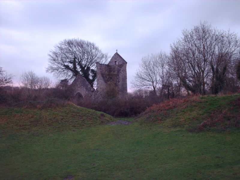
Location: A small church set in the north-east corner of Caerau Camp Hill Fort on the south-east side of the Community.
County: Cardiff
Town: Cardiff
Community: Caerau
Community: Caerau
Built-Up Area: Cardiff
Traditional County: Glamorgan
Tagged with: Church building
Present structure said to date from C13. Restored c1885 by John Prichard, Llandaff diocesan architect, who rebuilt the chancel. The vestry was added in c1920. The church is now wholly ruined and fragmentary. Formerly with oval churchyard.
The church was not accesssible at resurvey; it is fenced off with access forbidden for safety reasons. It is thus not possible to check the survival of the features described at the time of listing (August 1980). Superficially the church appears to be in a far more damaged and fragmentary state than when it was listed and when it was described by John Newman in c1995.
The ruins of a medieval church. Stone walls, mostly stone rubble; once with slate roofs. West saddleback tower, nave with south porch and north vestry; chancel. Only the tower survives in anything like a complete state.
West tower with battered walls; blocked stone framed west doorway with relieving arch over; small rectangular opening set high in west wall with similar opening also in east wall. A rectangular slit opening set lower in south wall above a further rectangular opening. Small circular belfry opening set high in North wall with stone canopy on corbels over it.
South wall of nave with single light round headed window with sunk spandrels at west end, set close to gabled south porch, the rebuilt front wall of porch of coursed stone with round-headed arch with stone voussoirs; south-east nave window of two cusped ogee lights in square frame. North wall of nave with gabled structure, possibly vestry, to west (not shown on OS map of 1920) lit by a 2-light window of golden stone in its north gable. North-west nave window comprises a cusped single light in grey stone frame. Chancel lit by cusped single light window of golden stone in north wall, by 2-light window in east gable and by damaged 2-light window with broken dripstone and missing mullions in south chancel wall.
Not available for inspection at resurvey. The church is unroofed and the interior gone.
This building is now very ruinous, but remains an important medieval site within the ringwork of Caerau Camp.
External links are from the relevant listing authority and, where applicable, Wikidata. Wikidata IDs may be related buildings as well as this specific building. If you want to add or update a link, you will need to do so by editing the Wikidata entry.


Other nearby listed buildings
