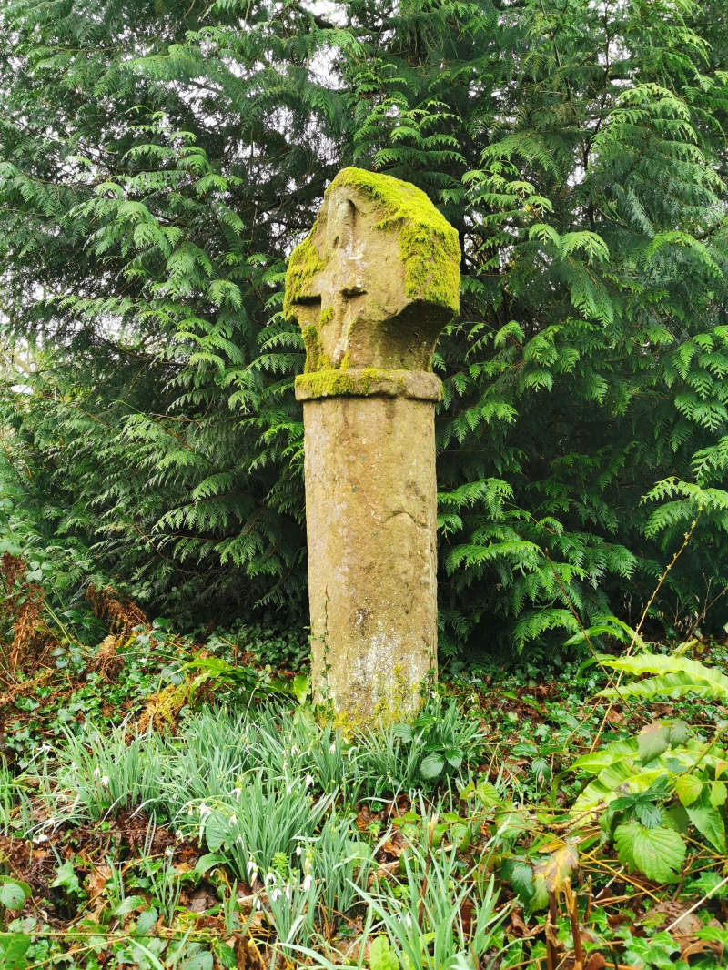
Cross at Croes Lwyd
A Grade I Listed Building in Raglan, Monmouthshire
Coordinates
Latitude: 51.7584 / 51°45'30"N
Longitude: -2.8699 / 2°52'11"W
OS Eastings: 340053
OS Northings: 206992
OS Grid: SO400069
Mapcode National: GBR JC.0DTD
Mapcode Global: VH79P.62NB
Plus Code: 9C3VQ45J+92
Entry Name: Cross at Croes Lwyd
Listing Date: 31 January 2001
Grade: I
Source: Cadw
Source ID: 24716
Building Class: Religious, Ritual and Funerary
Also known as: Cross at Croes Llwyd Farm, Raglan
ID on this website: 300024716
Location: Situated on S side of Broom Lane about 400m E of Broom House, at the bottom of the garden at Whitecross Cottage.
County: Monmouthshire
Town: Raglan
Community: Raglan (Rhaglan)
Community: Raglan
Traditional County: Monmouthshire
Tagged with:
Preaching cross
History
Monolith shaft and head of a medieval preaching cross. The cross was situated on the former boundary of the C15 Lordship of Raglan and is specifically mentioned in the grant of the Lordship to William Herbert in 1465.
Exterior
Stone cross and top of octagonal shaft hewn from a single piece of stone. The top of the shaft has a very plain flat capital and the head has raised Greek cross and raised border to rough 8-sided head, the diagonal sides concave-curved.
Reasons for Listing
Included as a very rare survival of a medieval boundary marker.
Scheduled Ancient Monument MM156.
External Links
External links are from the relevant listing authority and, where applicable, Wikidata.
Wikidata IDs may be related buildings as well as this specific building. If you want to add or update a link, you
will need to do so by editing the Wikidata entry.
Recommended Books

Somerset: North and Bristol: The Buildings of England (Pevsner Architectural Guides) (Pevsner Architectural Guides: Buildings of England)
Listed Buildings: The Law and Practice of Historic Buildings, Ancient Monuments and Conservation Areas
Historic Environment Law: Planning, Listed Buildings, Monuments, Conservation Areas and Objects by Harwood, Richard (2012) Paperback
Bedfordshire, Huntingdonshire, and Peterborough (Pevsner Architectural Guides): Written by Charles O'Brien, 2014 Edition, Publisher: Yale University Press [Hardcover]
The Victorian House Manual (2nd Edition): How They Were Built, Improvements & Refurbishment, Solutions to All Common Defects - Includes Relevant ... ... Properties (Haynes Manual) (Haynes Manuals)
The Shredded Chef: 120 Recipes for Building Muscle, Getting Lean, and Staying Healthy
Other nearby listed buildings
-
II
Broom House
Situated about 1. 5 km SW of Raglan, on S side of Broom Lane which runs W from the Usk road. Broom House is about 150m down Broom Lane and within its own walled grounds.
-
II
Agricultural labourers cottage
Situated approx. 2 km SW of Raglan on Broom Lane which is a by-road to Rhiw-las off the Usk Road. On N side of lane some 600m E of Broom House.
-
II
Raglan Baptist Chapel
Situated set back from Usk Road in lawned yard, approached by path from road.
-
II
Including former store to rear
Situated prominently on the High Street, adjacent to Raglan Post Office.
-
II
Raglan Post Office
Prominently sited on the High Street in Raglan.
-
II
Telephone Call-box
Situated some 50m W of junction with Chepstow Road opposite Beaufort Arms Hotel.
-
II
Elm Cottages and attached outbuilding
Situated on W side of road, opposite primary school.
-
II
Castell Coch
Part of terraced row on W side of Castle Street, which runs N from Beaufort Square towards the castle.