Approximate Location Map
Large Map »
Latitude: 51.832 / 51°49'55"N
Longitude: -2.7144 / 2°42'51"W
OS Eastings: 350866
OS Northings: 215065
OS Grid: SO508150
Mapcode National: GBR FL.VM9V
Mapcode Global: VH86T.W6VX
Plus Code: 9C3VR7JP+R6
Entry Name: Old Inn Cottage
Listing Date: 10 August 2005
Last Amended: 10 August 2005
Grade: II
Source: Cadw
Source ID: 85183
ID on this website: 300085183
Location: On the main road going north out of Monmouth which rises slowly above the town.
County: Monmouthshire
Town: Monmouth
Community: Monmouth (Trefynwy)
Community: Monmouth
Locality: Buckholt
Traditional County: Monmouthshire
Tagged with: Cottage
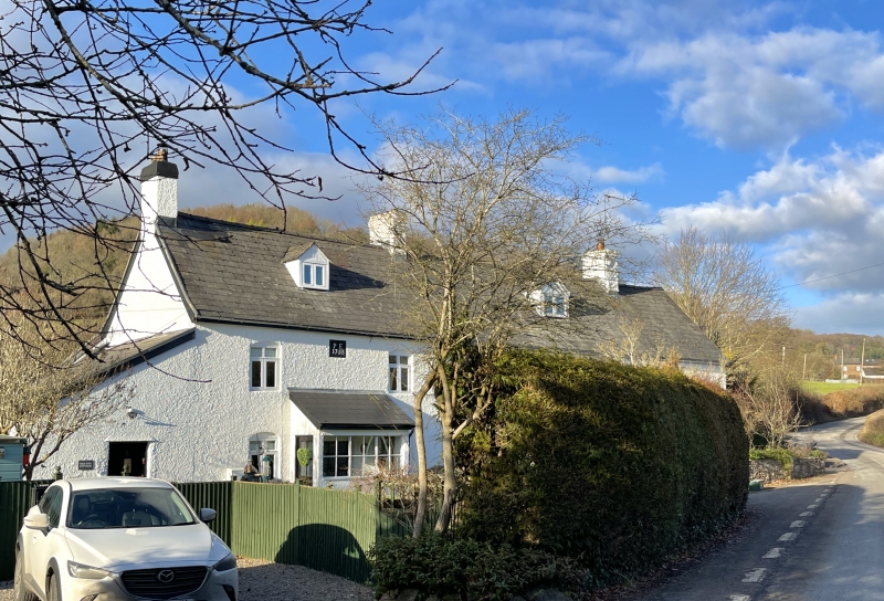
Possibly late C17 in origin and refurbished as dated 1755 PJE on plaque. Probably a part of the adjoining The Manson Inn until it closed in c1965. The initials are said to refer to the brother of Philip Endale who opened the inn in the C18.
Wholly rendered and painted, probably over rubble stone, with a Welsh slate roof. Single depth central entry plan with a continuous outshut on the rear elevation. Two storeys and attic, two windows. Door not seen. Windows are cross-framed casements in elliptical heads. Central plaque under eaves inscribed 1755 PJE. Fairly steeply pitched roof with stack on gable and on junction with adjoining house.
Left return has a lean-to addition on the gable wall.
Rear elevation has long catslide roof coming low over the single storey outshut. Modern features, two rooflights in attic.
Interior not seen at resurvey.
Included for its special architectural interest as one of a pair of small Georgian houses on the outskirts of Monmouth.
External links are from the relevant listing authority and, where applicable, Wikidata. Wikidata IDs may be related buildings as well as this specific building. If you want to add or update a link, you will need to do so by editing the Wikidata entry.


Other nearby listed buildings
